
Geospatial analysis grounded in urban science: accessibility and walkability modelling, urban morphometrics, network analysis, interactive maps, and LLM agents that run spatial workflows for you.
THE CONTEXT
Geospatial Analysis as Decision Infrastructure
Cities generate vast amounts of spatial data — from building footprints and street networks to satellite imagery, census grids, and real-time sensor feeds. Turning this data into actionable intelligence requires not just technical capacity but deep understanding of urban systems: how accessibility shapes neighbourhoods, how morphology influences liveability, how networks determine connectivity, and how these relationships change across scales and contexts.
Urban Geo Analytics combines geospatial engineering with urban science. We do not simply process spatial data — we design analytical frameworks grounded in geographic theory and validated through peer-reviewed research. This dual foundation means our tools produce outputs that are not only technically correct but scientifically meaningful: indicators that planners can trust, models that researchers can cite, and maps that decision-makers can act on.
GEOSPATIAL TOOL DEVELOPMENT
Custom Pipelines, Interactive Maps, Hosted Platforms
Example of an interactive map we deployed: urban agglomerations and localities over time
URBAN MORPHOMETRICS & PLANNING ANALYSIS
Network Analysis, Accessibility, and Spatial Classification
Indicator calculation and interactive map deployment at regional scale (France)
LLMs & AGENTS FOR SPATIAL ANALYSIS
Language Models and Autonomous Agents for Urban Data
The rise of large language models (LLMs) and AI agent frameworks introduces a new layer of intelligence on top of traditional geospatial pipelines. Where conventional GIS workflows process spatial data through fixed, manually-authored sequences of operations, language models and agents can interpret natural language instructions, select and invoke the appropriate tools, and iterate autonomously toward an analytical objective — fundamentally changing what it means to interact with and extract insight from spatial data. These models and agents can run entirely on the client’s infrastructure: see Local & Private LLMs & Agents.
LLMs as a Natural Language Interface to Geospatial Data
LLMs can serve as a conversational interface to spatial databases and geospatial APIs. A planner who wants to know which census blocks within a 15-minute walk of a transit hub have above-average elderly populations and below-average green space coverage does not need to write a spatial query or navigate a GIS interface — they can ask in natural language. We build connectors that translate plain-language questions into structured spatial queries (PostGIS, GeoPandas, OSMnx), execute them against the appropriate data source, and return answers with accompanying map outputs.
Beyond query interfaces, LLMs also serve as automated narrators: given a set of indicators and a map, a language model can draft a spatial diagnostic — summarising patterns, flagging anomalies, and contextualising findings relative to benchmarks or planning objectives. This is particularly useful for producing standardised reports across large numbers of territories or for assisting teams who are expert in urban policy but not in spatial data science.
Autonomous Agents for Geospatial Workflows
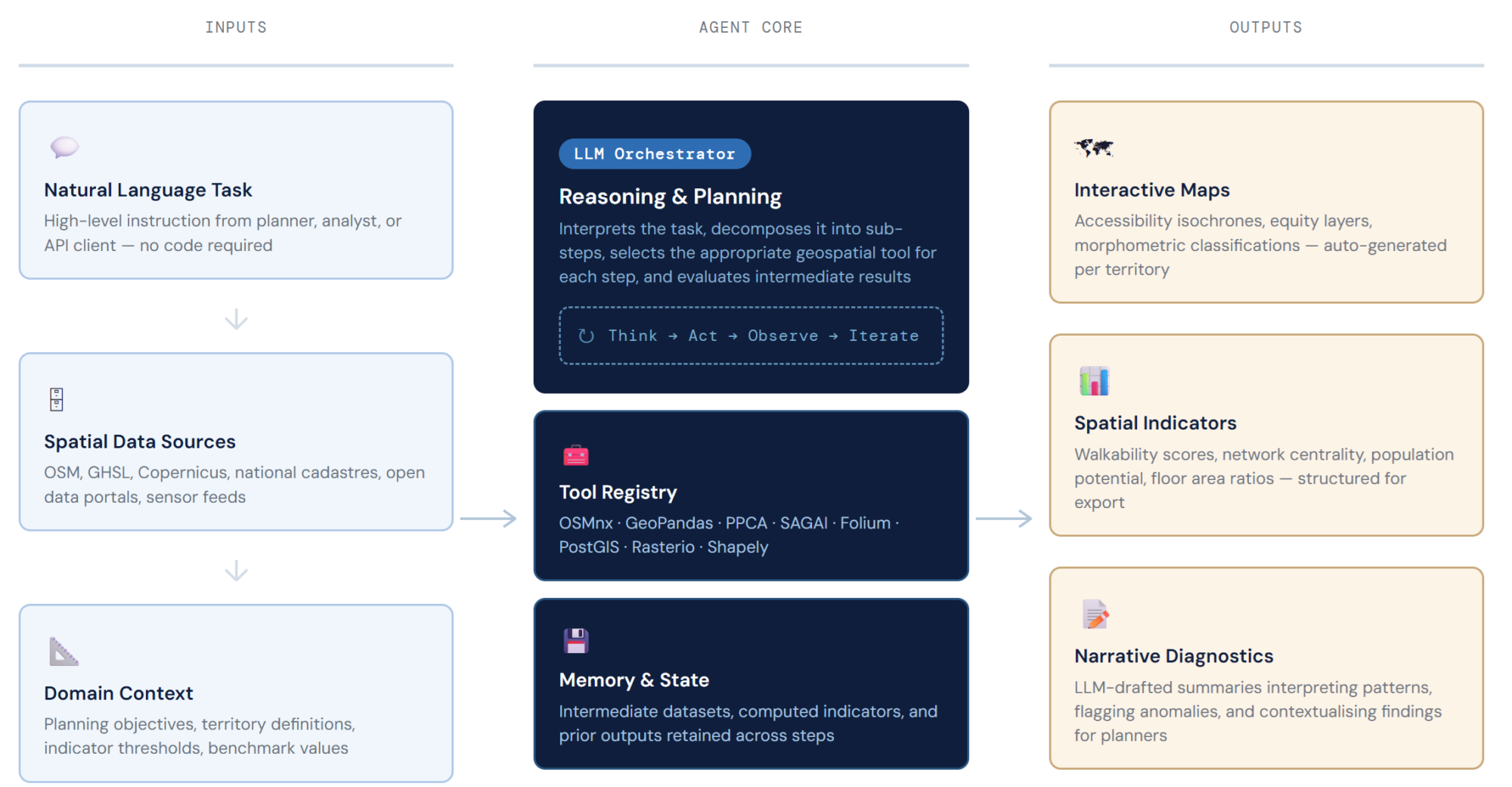
An AI agent is an LLM connected to a set of tools — functions it can call, APIs it can query, scripts it can run — and structured to pursue a goal through a sequence of reasoning and action steps. Applied to spatial data, an agent can receive a high-level task (“produce an accessibility diagnostic for the five districts with the lowest walkability scores in this region”), decompose it into sub-tasks (fetch network data, compute isochrones, overlay population, rank districts, generate maps, draft summary text), execute each step using the appropriate geospatial tool, and iterate when intermediate results require adjustment — without human intervention at each step.
We build spatial agent frameworks in Python using LangChain and custom tool registries that expose our geospatial pipelines as callable functions. The agent’s tool set typically includes: OpenStreetMap data retrieval (OSMnx), population and land-use raster queries (GHSL, Copernicus), morphometric indicator computation, network analysis (accessibility, centrality), spatial join and overlay operations, and map output generation (Folium, Deck.gl). The LLM — operating as the orchestrator — decides which tools to call, in what order, and how to interpret intermediate results to proceed toward the final output.
What This Enables in Practice
OPEN-SOURCE FOUNDATION
Backed by PPCA, SAGAI and UVLM
Our geospatial work is built on open-source tools we develop and maintain, and that anyone can inspect and reuse. PPCA and SAGAI are published in peer-reviewed journals: the methods we deploy for clients are the ones we have published.
All our tools: Software & Algorithms.
Need spatial analysis, urban modelling, or a custom geospatial tool? Get in touch.