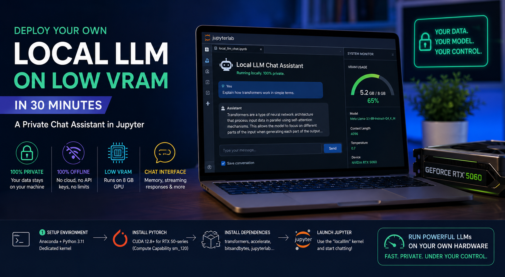
Joan Perez

About Joan Perez

This author has not yet filled in any details.
So far Joan Perez has created 13 blog entries.

A Stable and Reproducible Vision–Language Inference Engine for SAGAI v1.1

SAGAI v1.1 introduces Module 3 v2.0, a stable and reproducible vision–language inference engine for streetscape analysis. Built exclusively on Hugging Face LLaVA models, it enables robust multimodal processing of street-level images for large-scale urban and geospatial analysis.

2025-12-17T17:07:11+00:00December 17, 2025|Categories: Python, Urbanism, Vision Language Model|Tags: , , , , |0 Comments

Qwen Image Edit for Urbanism v1.3 — Mask-Controlled Editing With Prompt or Reference Guidance

Version 1.3 of Qwen Image Edit for Urbanism introduces mask-controlled editing in ComfyUI, enabling precise, localized image transformations using prompts or reference images. The new Grow Mask utility softens boundaries, preserves unmasked areas, and integrates seamlessly with existing single-image and sequential workflows.

2025-12-04T22:18:54+00:00December 4, 2025|Categories: Advanced, Diffusion Models, Urbanism|Tags: , , , |0 Comments

Deploy a Guest Book on an EVM Blockchain Using Remix

Learn how to deploy your first smart contract on an Ethereum-compatible blockchain using Remix and the Sepolia testnet. In this beginner-friendly guide, we build a simple on-chain guestbook, connect MetaMask, verify the contract on Etherscan, and interact with it directly through the blockchain. A perfect starting point for anyone curious about smart contracts, Solidity, and decentralized applications.

2025-11-27T16:17:44+00:00November 27, 2025|Categories: Blockchain, Intermediate|Tags: , , , , |0 Comments

Qwen Image Edit for Urbanism v1.2 — Custom Nodes & Sequential Processing

ComfyUI Sequential Image Editing for Urbanism arrives in Qwen v1.2 with custom Python nodes, multi-image batch processing, and a six-slot buffer for reproducible urban edits. This version streamlines automated workflows for researchers, designers, and architects working with street and neighborhood imagery.

2025-12-04T20:14:41+00:00November 17, 2025|Categories: Advanced, Diffusion Models, Urbanism|Tags: , , , |Comments Off on Qwen Image Edit for Urbanism v1.2 — Custom Nodes & Sequential Processing

Qwen Image Edit for Urbanism v1.1 — Editing using a Reference Image and Advanced Sampling

Qwen Image Edit for Urbanism v1.1 expands local AI editing in ComfyUI with advanced sampling and dual-image workflows. The new Lightning LoRA system improves realism, texture fidelity, and processing speed, enabling fast, privacy-preserving urban scene transformation—entirely offline.

2025-11-14T09:53:20+00:00November 12, 2025|Categories: Advanced, Diffusion Models, Urbanism|Tags: , , |0 Comments

Qwen Image Edit for Urbanism v1.0 — Building a Qwen Pipeline in ComfyUI

Learn how to build a fully local AI image-editing workflow for urbanism and architectural visualization using ComfyUI and Qwen-Image-Edit. This step-by-step guide runs entirely offline with GGUF models, providing fast, private, and realistic visual edits.

2025-11-13T23:46:53+00:00November 9, 2025|Categories: Advanced, Diffusion Models, Urbanism|Tags: , , |0 Comments

Getting Started with MetaMask and the Polygon Amoy Testnet

Learn how to configure MetaMask for the Polygon Amoy testnet, claim free POL tokens and verify your transactions. Beginner‑friendly guide.

2025-11-08T13:08:11+00:00November 8, 2025|Categories: Blockchain, Getting Started|Tags: , , |0 Comments

Processing Spatial Data in the Cloud with GeoPandas and Google Colab

Learn how to process geospatial data entirely in the cloud using GeoPandas, Google Colab, and Drive. Create, analyze, and save maps without local setup.

2025-11-08T16:44:18+00:00November 7, 2025|Categories: Cloud computing, GIS, Intermediate, Python|Tags: , , , , |0 Comments

How to import a GeoPackage layer in Python (geopandas) and R (sf)

GeoPackage is an open and non-proprietary data format that allows different layers to be stored within the same file. In this post, we are going to read and save layers using python (geopandas) and R (sf).

2025-11-07T12:12:17+00:00May 13, 2024|Categories: GeoPackage, Getting Started, Python, R|Tags: , , , , , |0 Comments

Install R and RStudio for Spatial Analysis

R is an open-source statistical programming language used in statistical analysis but also in spatial analysis, artificial intelligence (AI), and machine learning (ML) applications. In this guide, we will walk you through the initial steps of setting up R and RStudio along with installing essential packages and testing them with spatial data.

2025-11-07T11:19:57+00:00April 24, 2024|Categories: Getting Started, GIS, R|Tags: , , , , |0 Comments